A common mistake we see from developers in Dundee is assuming the steep slopes along the Law and the Sidlaw Hills are stable because they have been vegetated for decades. Without a proper landslide assessment, shallow translational failures triggered by prolonged winter rainfall often go undetected until a retaining wall cracks or a garden slips. Our team uses detailed field mapping and borehole logging to identify slip surfaces, then couples that data with a study of slope stability to calculate factors of safety under drained and undrained conditions. We also run borehole permeability tests on the till deposits to understand how groundwater builds up after heavy storms.
The highest landslide risk in Dundee coincides with the steep slopes underlain by glacial till that becomes saturated after consecutive days of heavy rain.
Process overview
- Walkover survey of tension cracks, scarps, and seepage zones
- Hand auger or window sampler to 3–5 m depth for disturbed samples
- Installation of standpipe piezometers to monitor pore pressure response
- Shear box testing on undisturbed samples to derive peak and residual strength
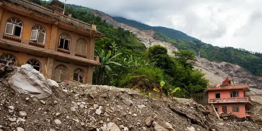
Local context
We deploy a tracked mini-excavator to dig shallow test pits on accessible slopes in Dundee, while on steeper wooded areas we use a portable hydraulic drill rig that can be carried in by hand. The team drills continuous core through the till and into the underlying sandstone, logging every change in lithology and measuring water strikes immediately. We then seal the borehole with a piezometer and data logger to record pore pressure fluctuations over at least two weeks. This physical setup lets us pinpoint the exact depth where the soil loses strength and the slope begins to move — critical information for any near-scarp development.
Visual overview
Reference standards
Eurocode 7 (EN 1997-1:2004) – Geotechnical design, BS 5930:2015 – Code of practice for ground investigations, FHWA-NHI-05-089 – Slope stability reference manual
Additional services
Detailed Slope Stability Analysis
Limit equilibrium analysis using Bishop's method and Spencer's method for circular and non-circular slip surfaces. Includes sensitivity analysis on groundwater level and shear strength parameters. Output includes safety factors for static and pseudo-static conditions.
Remedial Design Support
After identifying the failure mechanism, we design drainage measures such as French drains and horizontal wells, and recommend soil nailing or anchored walls to increase stability. We coordinate with structural engineers to integrate the solution with the building foundation.
Typical parameters
Quick answers
How much does a landslide assessment cost in Dundee?
For a typical residential slope in Dundee, the cost ranges between £800 and £3.380 depending on the number of boreholes, depth of investigation, and laboratory testing required. A basic walkover survey with two hand auger holes starts at the lower end, while a full investigation with piezometers and shear box testing reaches the upper figure.
What is the difference between a walkover survey and a detailed geotechnical assessment?
A walkover survey is a visual inspection of the slope surface — looking for tension cracks, displaced fences, and seepage zones. A detailed assessment includes drilling boreholes, installing piezometers, and running laboratory tests on soil samples to measure shear strength and pore pressure. The walkover identifies where the problem is; the detailed assessment tells you how close the slope is to failure and what to do about it.
Does the landslide assessment account for earthquakes?
Yes, we can include pseudo-static seismic analysis using a horizontal seismic coefficient of 0.05g (typical for the Dundee region) following Eurocode 8 requirements. For most slopes in the city, seismic loading does not govern the design, but we check it as a service for projects near critical infrastructure.
How long does a typical landslide assessment take?
A straightforward walkover survey with two boreholes can be completed in 3–5 working days. If we install piezometers and monitor pore pressure for two weeks, the full cycle from fieldwork to final report takes approximately 3 weeks. We can accelerate the programme by using continuous sampling and rapid laboratory turnaround.