Ground investigation in Dundee forms the critical first step in understanding the subsurface conditions that will directly influence the safety, design, and financial viability of any construction or civil engineering project. This category encompasses the full spectrum of intrusive and non-intrusive techniques used to assess soil, rock, and groundwater, from initial desk studies to detailed in-situ testing and laboratory analysis. In a city with such a complex post-industrial and glacial legacy, skipping a thorough investigation is not an option; it is the foundation upon which all successful developments are built, ensuring that unexpected ground conditions do not lead to costly delays, structural failures, or environmental harm.
Dundee's geology presents a particularly challenging environment that demands a robust investigative approach. The city is underlain by a mix of glacial till, sands, and gravels deposited during the last ice age, often overlying the Devonian Old Red Sandstone bedrock. This can create highly variable ground conditions across relatively short distances, with pockets of soft, compressible clays sitting alongside dense, boulder-rich tills. Furthermore, Dundee's rich industrial history means that made ground and potential contamination are widespread, especially along the waterfront and in former mill and factory areas. Understanding this intricate geological tapestry is paramount to designing appropriate foundations and managing geotechnical risk.
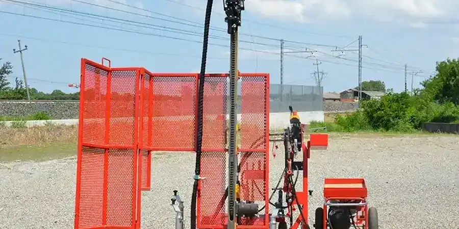
All ground investigation work in the UK, and therefore in Dundee, must comply with the rigorous standards set out in Eurocode 7 (BS EN 1997) and its associated UK National Annex, which governs geotechnical design. The execution of the investigation itself is typically carried out in accordance with BS 5930, the code of practice for site investigations, which provides detailed guidance on everything from borehole spacing to sampling frequency. For projects involving potentially contaminated land, the phased approach outlined in the Environment Agency's Land Contamination Risk Management (LCRM) framework is the definitive guide. Adherence to these standards is not merely best practice; it is a legal and contractual necessity to demonstrate due diligence and secure regulatory sign-off from bodies such as the Dundee City Council and SEPA.
The range of projects that necessitate a comprehensive ground investigation in Dundee is vast. Major infrastructure works, such as the ongoing waterfront regeneration, rely heavily on data from techniques like the CPT (Cone Penetration Test) to map soil stratigraphy and inform deep foundation design for quayside structures. Smaller-scale residential developments frequently require a combination of exploratory test pits to visually inspect shallow soils and trial pitting for soakaway design. For multi-storey commercial buildings, the SPT (Standard Penetration Test) remains a staple in boreholes to assess the density and strength of granular soils, providing essential parameters for pile design. Any project involving the sale or refinancing of land will also trigger the need for a Phase I and II investigation to address potential contamination liabilities.
Quick answers
What is the difference between a Phase 1 and Phase 2 ground investigation?
A Phase 1 investigation is a non-intrusive desk study that collates historical maps, geological records, and environmental data to develop a preliminary risk assessment for a site in Dundee. A Phase 2 investigation is the intrusive phase that follows, involving physical sampling via boreholes or exploratory pits to verify the Phase 1 findings and quantify geotechnical properties or contamination levels.
Why is ground investigation so important for projects in Dundee's Waterfront area?
The Dundee Waterfront is largely built on reclaimed land and thick sequences of soft alluvial and marine deposits overlying glacial till. This creates a high risk of variable ground conditions, potential contamination from historical dockland uses, and complex groundwater regimes. A detailed investigation is vital to design deep foundations, manage settlement, and ensure long-term stability for major structures.
How deep should a typical ground investigation borehole be in Dundee?
The depth is not fixed and depends entirely on the proposed structure and the anticipated geology. For a lightly loaded residential foundation on glacial till, 5 to 10 metres might suffice. However, for a piled high-rise building on the Waterfront, boreholes often need to extend 30 metres or more to reach competent bedrock (Old Red Sandstone) and prove it beyond the zone of influence of the foundations.
What UK regulations govern the assessment of contaminated land during an investigation?
The primary framework is the Environment Agency's Land Contamination Risk Management (LCRM), which replaced the CLR 11 model procedures. It outlines a phased, risk-based approach for identifying, assessing, and managing land contamination. In Scotland, this operates under the Environmental Protection Act 1990 (Part IIA) and is enforced locally by Dundee City Council, with SEPA acting as a statutory consultee on controlled waters.